
Acworth ZIP Directory Coverage
Two ZIPs form the postal core, while a third demonstrates the reverse mismatch between mailing and legal city identity. The table reflects official USPS facilities and the City of Acworth boundary explanation. It does not turn a postal area into a municipal boundary. The incorporated city is wholly in Cobb County, but an Acworth mailing line can reach parts of Cobb, Cherokee, Paulding, or Bartow. The right county custodian therefore depends on the parcel, not the city name printed after the street.
| ZIP Code | Areas Covered | Post Office | Notes |
|---|---|---|---|
| 30101 | Downtown and historic Acworth; broad western and northern mailing territory | Acworth Main, Brookstone, and carrier/S&DC | Extends beyond city limits into Cobb and postal areas tied to Paulding and Bartow |
| 30102 | Eastern Acworth mailing territory, Highway 92 and Oak Grove, reaching Cherokee | Oak Grove Station retail site was slated for relocation | USPS announced its relocation decision in October 2024 |
| 30144 | Some parcels legally within Acworth | Kennesaw Post Office | A city resident may carry a Kennesaw mailing line |
The USPS routing list groups 30101 and 30102 under Acworth. No official local PO-box-only ZIP, unique ZIP, dated citywide split, or official per-ZIP population table was found. Those categories should not be added to the Acworth ZIP code directory just because they exist elsewhere.
30101 Acworth Postal Facilities
Acworth Main is at 4915 N Main Street. The Brookstone site is at 5330 Brookstone Drive NW, Suite 250, and the carrier and sorting facility is at 4200 McEver Industrial Drive NW. These sites serve mail operations within the broad 30101 territory. A post office location does not establish the city line around a house, nor does it decide which county keeps a deed or tax parcel.
The official USPS Acworth Main listing supplies the source screen below.
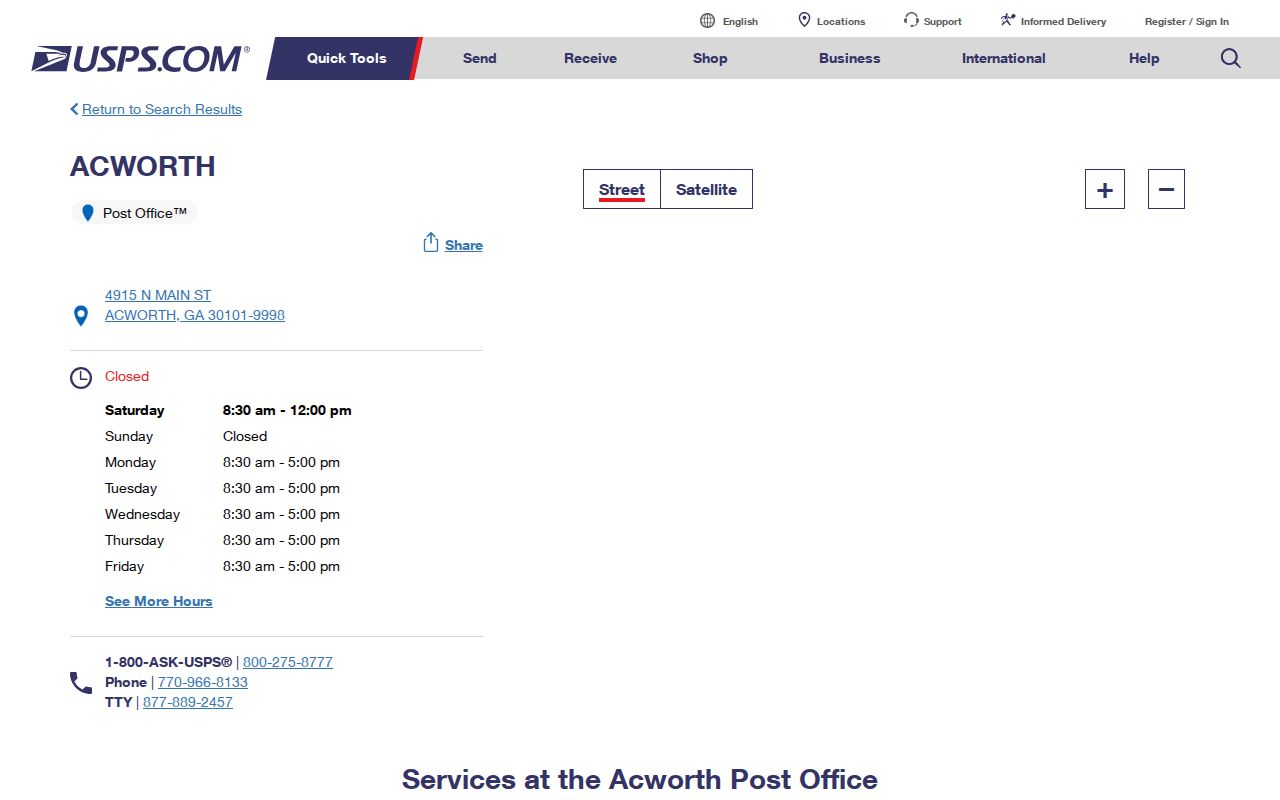
Check that listing for current postal services and facility details, then use an address lookup for the mail route itself.
A second USPS Acworth facility listing documents another local postal point.
Together, the facility records explain service points without claiming that either building defines the edges of 30101.
Acworth ZIP 30102 Changed Service
ZIP 30102 covers eastern Acworth mailing territory around Highway 92 and Oak Grove and extends into Cherokee County. After the lease was not renewed at 5944 Highway 92, USPS considered options for Oak Grove retail operations. In October 2024, it announced a decision to relocate that retail service, while a replacement location was still being chosen.
The dated USPS Oak Grove relocation decision is captured below.
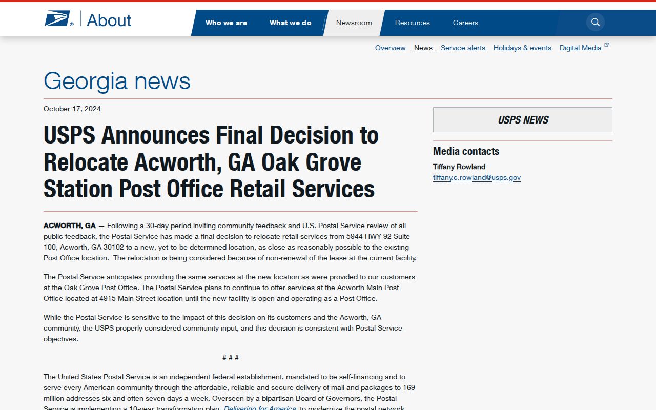
The notice concerns the retail station, not a documented change to the ZIP boundary. Treat the facility move and the delivery geography as separate facts.
Note: Confirm the current Oak Grove retail location with USPS because the 2024 notice did not name the replacement site.
Search Acworth Residents by ZIP
The available official tools do not all accept the same input. USPS is the authority for matching an address to its ZIP code. Georgia's My Voter Page verifies one registered voter from identifying information, but it cannot browse everyone in a ZIP. A lawfully ordered Georgia voter file contains a Residence Zipcode field that can be filtered. Cobb's simple assessor address form expressly tells users to omit the ZIP, while Cobb GIS can be used for spatial browsing through its live map tools.
- Verify the complete mailing address with the official USPS ZIP lookup. Save the standardized city and ZIP result.
- Check the parcel and tax district through Cobb GIS or the assessor. This determines whether “Acworth” means the legal city or only the mailing name.
- For a lawful voter-data project, request the official file through Cobb Elections and filter its Residence Zipcode field. Do not treat My Voter Page as a block browser.
- Use the GIS map to narrow the postal area to parcels, roads, or a tax district. Once the target becomes a named road, continue through the Acworth street directory process.
| Official tool | ZIP input | What it can confirm | Key limit |
|---|---|---|---|
| USPS ZIP lookup | Address, city/state, or city-and-ZIP modes | Authoritative postal match | Not a resident or ownership roll |
| Georgia voter file | Residence Zipcode column | Lawfully released voter rows by ZIP | Protected records withheld; commercial use prohibited |
| My Voter Page | No ZIP browse | One person's status, polling place, districts, and ballot details | Requires identifying data |
| Cobb property form | ZIP rejected in the simple address field | Parcel match from house number and street | Use parcel or GIS to test city limits |
When no online screen returns the needed existing record, a written request is the fallback. Georgia's Open Records Act, O.C.G.A. §§ 50-18-70 through 50-18-77, sets a three-business-day response or production rule. The office need not create a new ZIP report, so name the existing voter file, parcel record, map layer, or issued-address record and state the desired date range.
Test Acworth City Residency
The City of Acworth boundary FAQ states the central rule: an Acworth mailing address does not prove that an address lies within city limits. Incorporated Acworth is in Cobb County, while Acworth mail reaches four counties. The reverse also occurs because some legal city parcels receive Kennesaw mail under 30144.
The city's official explanation appears in the source image below.
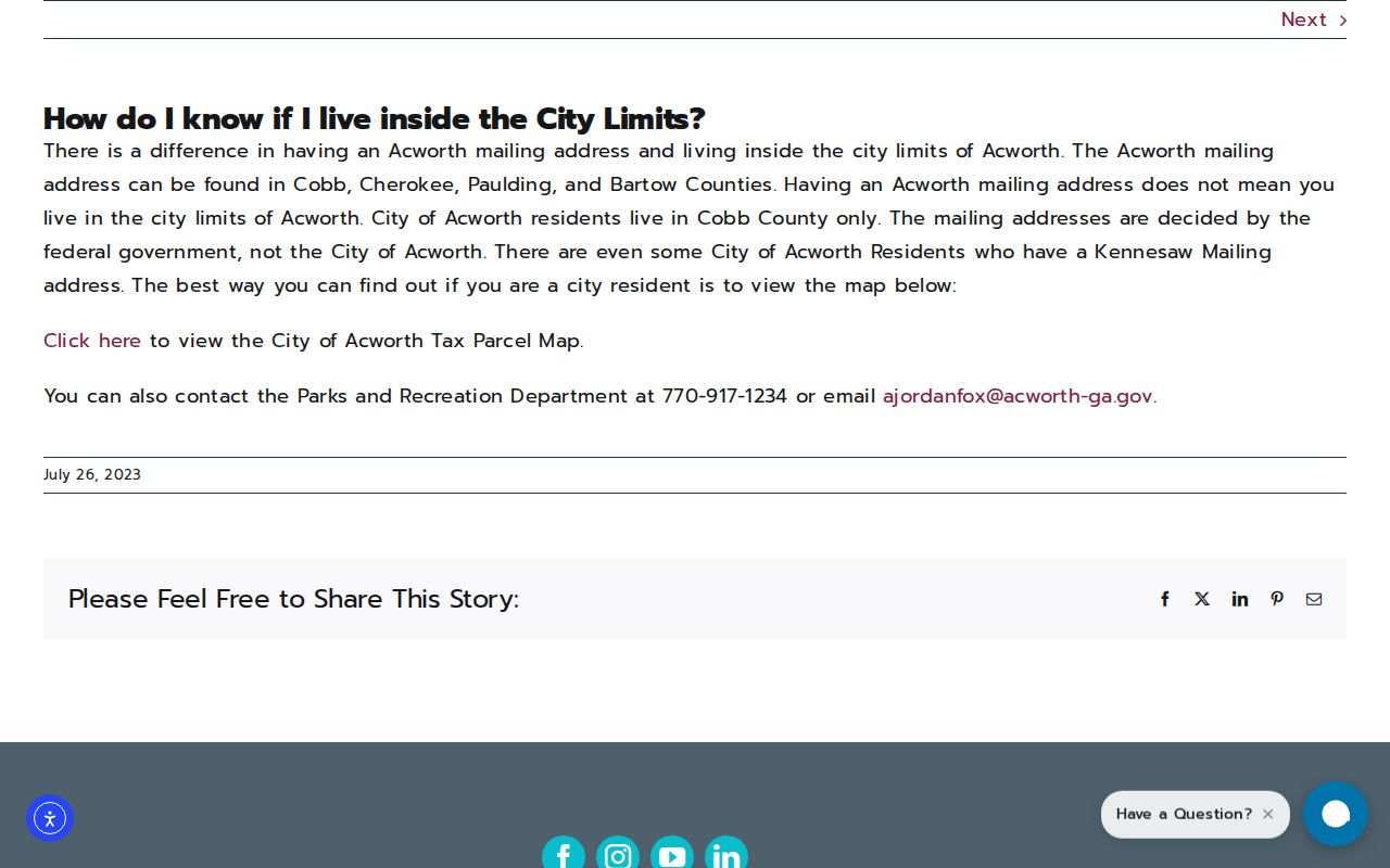
Use the City Tax Parcel Map or contact Parks and Recreation at (770) 917-1234 or ajordanfox@acworth-ga.gov when the parcel view needs confirmation.
Acworth ZIP and City Boundaries
The Acworth ZIP code directory answers postal questions. It cannot establish legal residence, ownership, or record custody by itself. A 30101 or 30102 line may point outside incorporated Acworth, and a 30144 line can point inside. The city's GIS staff assigns new addresses inside city limits and maintains city mapping. Acworth Development operates from City Hall at 4415 Center Street on weekdays from 8 a.m. to 5 p.m., while plats approved through development are recorded by the Cobb Superior Court Clerk.
- ZIP and ZIP+4
- A ZIP identifies a broad delivery area. The extra four digits narrow mail toward a smaller delivery segment.
- PO-box ZIP
- A postal code reserved chiefly for boxes rather than normal street delivery. None was officially verified for Acworth.
- Unique ZIP
- A code assigned to one large recipient or institution. No Acworth example was established.
- Carrier route
- A delivery path within postal geography. It does not create a city, county, or parcel boundary.
Legal descriptions survive postal change. Cobb land records may identify land lot and district, subdivision lot and block, a recorded plat, or metes and bounds. A situs address names the physical parcel. An owner mailing address is for contact or delivery and can be somewhere else. Keeping those keys apart prevents a nonresident owner from being mistaken for an occupant.
Acworth ZIPs Overlay an Older Grid
Modern ZIP geography sits over a much older civic pattern. Acworth began around the Western & Atlantic depot. Its incorporated limit was a half-mile radius on December 1, 1860, then a one-mile radius after reincorporation in 1870. The Main, Center, Lemon, and Collins street grid still reflects that rail-centered origin. Today's postal territory stretches far beyond that early circle.
This explains why a historical Acworth reference may describe the town, community, station, or postal area rather than today's legal boundary. For older research, carry the street, land lot, district, subdivision, and deed citation along with the name. Modern planning terms such as Historic, Parkside, and Mill Districts add civic context but are not ZIPs and are not resident rolls.
Note: Do not assign a historical record to present city limits solely because its place line says Acworth.
Route Acworth ZIP Records Correctly
Once a parcel is confirmed inside incorporated Acworth, city records may cover municipal permits, assigned addresses, zoning, and code matters. Cobb County keeps the lasting property and deed trail. The Board of Tax Assessors supplies parcel data, Cobb GIS supplies map context, and the Superior Court Clerk records deeds and plats. If the postal address falls in Cherokee, Paulding, or Bartow instead, use that parcel's county offices.
A clear written request should name an existing record series, an address or parcel ID, and a date range. Ask Acworth Development for an issued-address or permit record that it keeps. Ask the relevant county for parcel or recorded land material. Do not ask an office to research everyone in a ZIP or create a new resident list. The office may provide web access, counter help, mail service, or an Open Records Act response depending on the record.
This routing step is why the ZIP code directory narrows the field but never completes an identity search alone. Verify through two independent records when the goal is to reconnect with a relative, locate an heir, research a historic home, or confirm a public filing.
City and county counters remain useful when a live portal cannot expose the needed field. Acworth Development can address city mapping and assigned-address questions. The Cobb assessor and GIS teams handle parcel identity and tax-district context. The Superior Court Clerk's Real Estate Division holds official deeds and plats at 10 East Park Square, Building C, in Marietta, with web, counter, and mail channels. A request should preserve the standardized postal address, parcel ID, and legal description so staff can distinguish delivery geography from recorded land identity.
Postal verification also has a non-web route through a USPS facility. Bring the complete street line and unit when relevant. For government records, call or visit the proper custodian if the online form rejects a ZIP or returns no match. These fallback channels are part of a sound Acworth ZIP code directory search because a blank web result does not prove that the address, parcel, plat, or voter record does not exist.